 Michał Chromiak's blog
 A photograph records one view of a scene. Move the camera and much of the world is missing: the back of an object, the room beyond a doorway, and the geometry hidden behind a wall were never captured. A useful world model must do more than make attractive pixels. It must keep track of what has already been observed, respect where the camera is, and decide what can be reconstructed versus what must be inferred.
Atlas is World Labs' attempt to put those jobs inside one model. Announced on September 1, 2026, it accepts combinations of text, images, camera poses, and depth maps. It can then generate new views, reconstruct explicit 3D geometry, reframe video, or supply simulated observations for robotics workflows. World Labs calls it an omni world model because the same pretrained architecture supports several input and output types rather than assigning each task to a separate specialist model. Official Atlas introduction.
Atlas is a model from the World Labs team, a company co-founded by Fei-Fei Li, Justin Johnson, Ben Mildenhall, and Christoph Lassner. It is more precise to describe it this way than to attribute the model to one researcher. World Labs team.
Figure 1. Official Atlas launch artwork. (Source: World Labs).
The short version🔗
- What goes in: text, images, camera poses, and depth maps. A video is represented as a sequence of images.
- What comes out: images, video frames, depth maps, point clouds, or 3D Gaussian splats, depending on the task.
- What makes it different: images and depth maps are tied to explicit camera poses, so viewpoint is part of the model's input rather than only a sentence such as "move the camera left."
- How it generates: Atlas predicts a sequence one element at a time and uses rectified-flow diffusion to construct high-dimensional outputs such as images.
- What has been shown: camera-controlled generation, sparse-view 3D reconstruction, video reframing, image generation, and components of real-to-sim workflows.
- What evidence is available: a World Labs technical report with demonstrations and two quantitative evaluations; no paper, model card, code, or public checkpoint accompanied the launch.
The public material is detailed enough to explain the design and inspect the reported evaluations, but not enough to reproduce the model.
What "world model" means here🔗
World Labs uses spatial intelligence for the ability to model and reason about objects, places, and interactions across space and time. Spatial intelligence is the broader goal; a world model is the learned system intended to support it. World Labs' description of spatial intelligence.
The term world model is overloaded. In model-based reinforcement learning, it often means a learned transition model: given a state and an action, predict what state comes next. In generative media, it may describe a system that produces navigable or temporally coherent scenes. In robotics, it can refer to a model that supports rendering, simulation, planning, or some combination of the three.
World Labs separates these roles into a useful taxonomy:
- A renderer predicts observations, such as the image a camera would see.
- A simulator predicts geometrically, physically, or dynamically faithful state, such as scene geometry or how objects change over time.
- A planner selects actions to reach a goal.
Atlas publicly demonstrates strong renderer capabilities and reports quantitative reconstruction results for geometry. Its physical and dynamic simulation examples are demonstrations rather than equivalent benchmark studies. A separate policy chooses robot actions; Atlas supplies observations rather than plans. World Labs' functional taxonomy.
Start with one scene🔗
Suppose you photograph a desk from the doorway. The image contains appearance information: colors, textures, lighting, and visible objects. If the model also receives the camera pose, that metadata specifies where the observation sits in a three-dimensional coordinate system and which direction the camera faced.
Ask for a view from behind the desk and the model has two kinds of work to do:
- Preserve evidence: visible objects should remain in compatible positions and keep a consistent appearance.
- Complete missing evidence: the far side of the desk and any occluded region must be inferred because the input did not contain them.
Atlas encodes the available observations into what World Labs calls a spatial context. Adding another photograph from the opposite side constrains that context. The model should need to invent less because more of the scene is now observed. This is the central idea behind both Atlas's controllable generation and its reconstruction workflow.
A plausible unseen region is not the same as a measured reconstruction. From one image, Atlas may produce a convincing continuation, but there is no way to verify that the hidden content matches the real location. More input views reduce ambiguity; they do not make every unobserved surface ground truth.
One Atlas request, end to end🔗
The public description can be reduced to four steps:
- Provide observations. Reference images, depth maps, text, and camera poses describe what is already known about the scene.
- Place them in context. The camera poses connect each image or depth map to a viewpoint in 3D space, forming the spatial context.
- Request another element. A target camera pose and output type specify what should be generated next, such as a color image or a depth map from a new view.
- Generate the output. The transformer conditions on the preceding elements, while rectified-flow diffusion constructs the requested image or depth map. Depth and camera information can then support explicit 3D representations.

Figure 2. Text, images, depth maps, and camera poses enter a shared spatial context. A target pose requests the next element, and rectified flow resolves its visual content. Based on World Labs' model description.
How the architecture fits together🔗
World Labs describes Atlas as a multimodal autoregressive diffusion transformer. Each word contributes a different part of the design.
Multimodal: several kinds of evidence share one context🔗
Atlas currently works with text, images, camera poses, and depth maps. An image says what a camera observed. Its pose says where the camera was and how it was oriented. A depth map estimates how far each visible point is from the camera. Together they provide more structure than pixels alone.
Calling the model multimodal does not mean every modality is interchangeable. Text describes a scene semantically; camera poses specify geometry; images and depth maps carry dense spatial measurements. The architecture's job is to condition generation on all of them coherently.
Autoregressive: produce the next element from earlier elements🔗
Atlas treats a task as a sequence of multimodal elements. It generates each new element conditioned on the elements already in the sequence. For example, a collection of reference images and poses can be followed by a requested camera pose and then the image Atlas predicts for that view.
This resembles a language model predicting the next token, but the unit being generated can be an image or depth map rather than a word fragment. The sequential design also makes familiar inference techniques such as key-value caching relevant.
Diffusion: construct a continuous output by denoising🔗
Images contain far more continuous detail than a small vocabulary of text tokens. Atlas uses a latent diffusion approach, specifically rectified flow, to generate those outputs by transforming noise toward a sample that fits the spatial context. Latent means the generative process works in a compressed numerical representation rather than manipulating every full-resolution pixel directly.
Autoregression generates each requested output element conditioned on prior elements. Diffusion constructs the content of that element through iterative denoising. They operate at different levels and are complementary, not competing descriptions of the same step.
Optional detail: What rectified flow is doing
At a high level, training shows the model clean examples and noisy starting points. The model learns a direction that moves a noisy representation toward data that resembles the training examples while satisfying the current context. During generation, it begins from noise and follows that learned flow to produce a new sample.
"Rectified" refers to learning comparatively direct transport paths between noise and data. Straighter paths can reduce the number of numerical steps needed during generation.
For the formal construction, see Liu, Gong, and Liu, Flow Straight and Fast: Learning to Generate and Transfer Data with Rectified Flow.
Transformer: combine information at scale🔗
The transformer processes relationships across the multimodal sequence. Its matrix-heavy computation maps well to modern accelerators, and it provides an architecture that can scale with data and compute. World Labs reports that larger internal training runs produced better performance and new capabilities. No model sizes or training curves are available yet to quantify that trend.
How Atlas differs from neighboring model families🔗
Atlas combines ideas that usually live in separate systems:
| System | What forms its context | What it predicts |
|---|---|---|
| Language model | A sequence of text tokens | The next token |
| Typical video generator | A prompt, reference media, and preceding frames | Pixels or latent video frames |
| Specialist 3D reconstructor | Calibrated views of a scene | Depth, points, camera parameters, or another geometric representation |
| Atlas | A sequence of text, camera-grounded images, poses, and depth maps | The next multimodal element, including an image or depth map |
The autoregressive transformer gives Atlas an expandable context, as in a language model. Rectified-flow diffusion constructs continuous outputs, as in modern image and video generators. Camera poses and depth make the sequence spatially explicit, while point maps and Gaussian splats connect generated views to 3D workflows. The unusual part is not any one component; it is their combination inside one pretrained model.
Why the design matters🔗
Viewpoint becomes a controlled variable. A text instruction such as “move left” describes an intention. A camera pose specifies a position and orientation. Atlas can therefore condition on the requested view directly instead of inferring the intended motion from language.
New evidence can constrain an existing world. One photograph leaves every hidden surface ambiguous. Add another camera-grounded view and the spatial context contains more measurements of the same scene. The model can preserve what is observed and reserve generation for the gaps.
Rendering and reconstruction share information. An image answers “what would this camera see?” A depth map also says where visible surfaces lie. Producing both from the same context lets Atlas move between visual generation, novel-view synthesis, and explicit geometry without treating them as unrelated tasks.
These advantages come from the structure of the input and output interface. They do not turn Atlas into a language reasoner or a robot planner; those systems solve different parts of a larger workflow.
What Atlas does in practice🔗
Follow an explicit camera path🔗
Many video generators receive camera direction as text: "pan left" or "crane upward." Atlas instead accepts camera geometry as a native input. A creator can specify the position and orientation for requested views, while reference images anchor the scene's content.
World Labs reports generation from one to six reference images, with manually designed paths and output up to one minute at 1440p. Its phrase "pixel-perfect camera control" refers to following the specified camera geometry, not to every generated pixel being a measured reconstruction of the source scene.
Reconstruct a scene from sparse views🔗
For reconstruction, Atlas receives images with their camera poses and predicts a 3D point for each input pixel. It can output new 2D views as well as explicit representations such as point clouds and 3D Gaussian splats. A point cloud is a set of sampled locations on visible surfaces, often carrying color as well as position. A Gaussian splat represents a scene as many translucent, oriented 3D primitives that can be rendered quickly from new viewpoints.
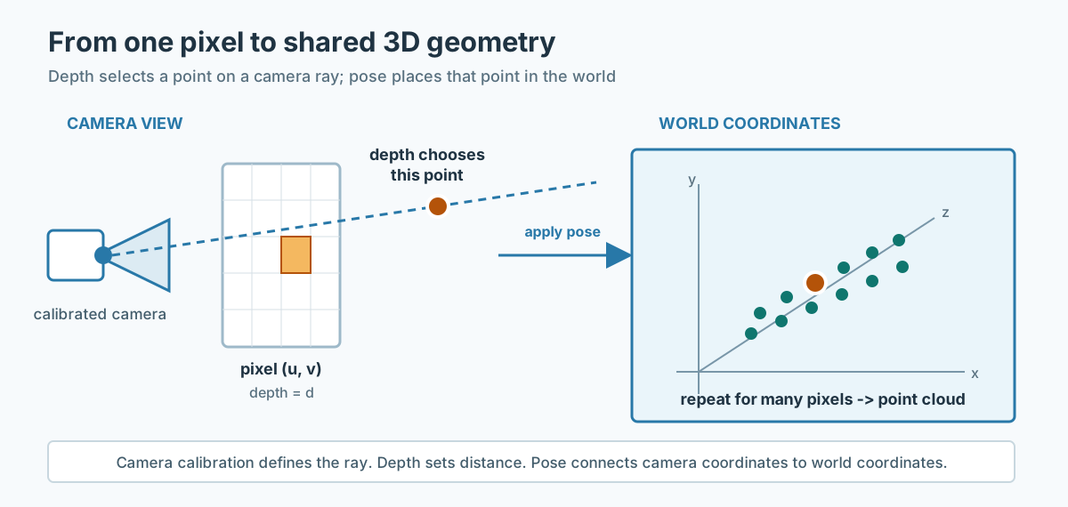
Figure 3. The geometric bridge from a depth map to a point cloud: calibration defines each viewing ray, depth selects a point on it, and camera pose places that point in shared world coordinates.
Optional detail: How a depth map becomes 3D
A pixel identifies a direction from the camera into the scene. Its depth value selects a point along that direction. The camera calibration defines the viewing rays, and the camera pose transforms each point from the camera's local coordinates into a shared world coordinate system.
Repeating this operation across the image produces a point cloud. A renderer can then display those points directly or convert them into a denser representation such as 3D Gaussian splats. This is the geometric intuition behind point-map reconstruction.
World Labs says Atlas can work with one to more than one hundred images. The examples illustrate a continuum: a few views invite more generative completion, while dense coverage provides stronger constraints on the real scene.

Figure 4. An Atlas example associated with explicit 3D output. Inspect the interactive demonstration to move through the scene. (Source: World Labs).
Reframe events in space and time🔗
Atlas can combine several synchronized recordings of an event and render a new camera trajectory through it. World Labs demonstrates "bullet time" style reframing from three to five ordinary cameras. This is more constrained than generating an arbitrary future: the cameras provide multiple observations of the same event, and the model synthesizes viewpoints between and beyond them.
The result is viewpoint synthesis through one recorded event rather than prediction of an arbitrary future.
Help construct robotics simulations🔗
In the navigation examples, a phone video supplies frames from a real environment. Atlas reconstructs the space and generates RGB and depth observations along simulated robot paths. For manipulation, World Labs presents Atlas as part of a real-to-sim system that can vary objects, positions, motion, lighting, and backgrounds. Atlas supplies the environment and sensor views in this workflow; a separate robot policy chooses actions.
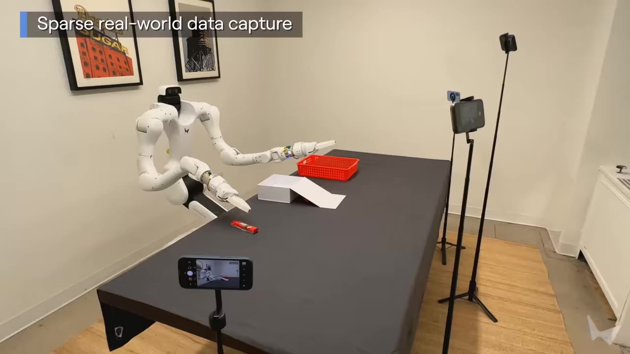
Figure 5. Sparse capture for an official Atlas robotics demonstration. Atlas contributes reconstruction and sensor-view generation; the complete workflow also requires robot, simulation, and policy components. (Source: World Labs).
How to read the reported benchmarks🔗
The launch report includes two quantitative evaluations: following a requested camera path and reconstructing 3D points from sparse views.
Camera-controlled generation🔗
Each trial pairs one source image with a target path containing one to three cinematic motions. Atlas receives the camera path in its native geometric format. Five comparison models receive text descriptions of the same motion because they do not accept camera poses directly. Third-party raters then choose which output follows the intended path better.
The reported share preferring Atlas ranges from 75% against MiniMax H3 to 94% against Seedance 2.5, with the other comparisons in between. Under World Labs' protocol, raters found Atlas better at following these camera trajectories.
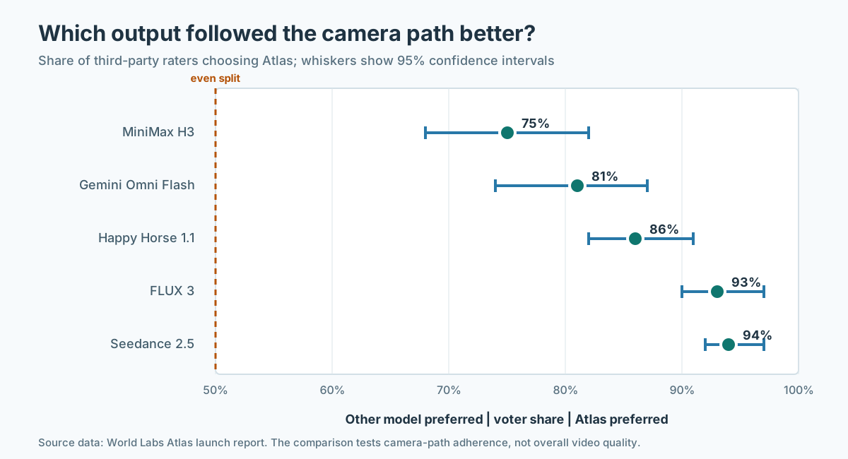
Figure 6. Share of raters who preferred Atlas for camera-path adherence. Atlas received explicit camera geometry; comparison models received text descriptions of the same motion. Data source: World Labs.
Because the conditioning interfaces differ, read this as a camera-control comparison rather than an overall video-quality ranking. Exact geometry is Atlas's product advantage; World Labs notes that stronger prompting might improve some text-conditioned baselines.
Sparse-view 3D reconstruction🔗
The reconstruction task asks each model to predict a 3D point for each input pixel. World Labs evaluates mean absolute-relative point-map error across DTU, ETH3D, KITTI, NRGBD, 7-Scenes, Tanks and Temples, and ScanNet. The company says it reproduced every baseline under a common protocol.
| Model | Average AbsRel ×10−3 |
|---|---|
| Atlas | 25.3 |
| Pi3X (posed) | 28.7 |
| π³ | 34.7 |
| VGGT-Ω 1B | 36.4 |
| Depth Anything 3 | 39.3 |
| MapAnything | 47.7 |
Lower is better. The chart's 25.3 × 10⁻³ is 0.0253 in ordinary decimal notation: a dimensionless relative-error aggregate, not a distance in meters. Atlas's average is about 12% lower than the nearest listed baseline, Pi3X. Data source: World Labs.
Atlas, Marble, and access🔗
Atlas and Marble are related but not interchangeable:
- Atlas is the newly announced foundation model and is in early access with selected partners.
- Marble is World Labs' existing product for creating and exporting navigable 3D worlds. Its public World API currently exposes Marble models.
- World Labs says Atlas will power future versions of Marble and other products.
For developers, the practical distinction is access: Atlas has no public weights or generally available API. Marble and the World API are available today, but their current behavior should not be treated as an Atlas evaluation.
When Atlas fits in a workflow🔗
Atlas is a strong conceptual fit when the task depends on where observations and requested views are located in space: directing a camera through a generated environment, completing a scene from sparse views, reframing a captured event, or producing varied sensor observations for simulation.
Use a different tool when another problem dominates:
- Choose a language model for text, code, retrieval, or symbolic reasoning. It may decide what spatial task to request, but it does not replace camera-grounded rendering.
- Choose a typed decision model when an enterprise agent needs a bounded categorical judgment from textual state. That is a decision interface, not a spatial simulator.
- Choose a general video generator when the priority is unconstrained visual storytelling and an exact 3D camera path or reusable geometry is unnecessary.
- Choose photogrammetry or a specialist reconstruction pipeline when the scene is densely captured and measurable fidelity, calibration control, and reproducibility matter more than learned completion of missing regions.
- Choose a robot policy or planner to select actions. Atlas can help construct the simulated world and generate sensor observations, but the policy still decides what the robot should do.
- Choose Marble or the current World API when public production access is required now; Atlas remains an early-access model.
In a creative pipeline, Atlas could sit between reference gathering and editing: artists provide anchor views, define camera poses, generate the missing viewpoints, and export images or geometry. In robotics, the sequence is different: capture a real environment, reconstruct it, vary conditions, generate observations along candidate paths, and use those observations to train or evaluate a separate policy. In both cases, Atlas is the spatial scene model inside the workflow, not the entire workflow.
The important unanswered questions🔗
Atlas points toward a useful unification of generation and reconstruction, but the public report leaves several questions open:
- Reproducibility: there is no public paper, model card, code, or checkpoint.
- Training data: the sources, filtering, licenses, geographic coverage, and privacy controls are not described in detail.
- Training recipe: the loss functions, task mixture, modality encoders, and spatial-conditioning representation are unpublished.
- Efficiency: parameter count, hardware requirements, latency, throughput, and per-task compute are unpublished.
- Geometry: average reconstruction error does not tell us how the model handles thin structures, reflections, moving objects, scale, or unseen regions in every setting.
- Physics: compelling short demonstrations do not establish stable contact dynamics, conservation laws, or long-horizon causal prediction.
- Robotics transfer: the launch examples do not isolate how much Atlas-generated simulation improves a policy on physical hardware.
These questions provide a practical checklist for evaluating a future paper, model card, or public release.
Why Atlas is worth following🔗
Atlas's most interesting contribution is the expandable spatial context: camera-grounded images, depth, and text can live together, and the model can return either pixels or explicit geometry from that context.
If this approach scales, the boundary between a video generator and a 3D reconstruction system becomes less rigid. A creator could direct a scene by placing observations in space. A robot developer could turn sparse recordings into varied simulation views. A reconstruction system could use learned priors when measurements are incomplete while accepting more evidence when fidelity matters.
Atlas brings rendering and geometric simulation closer together inside one architecture. Its clearest demonstrated strength is camera-grounded generation and reconstruction; planning stays with a separate policy, and physical fidelity is the next capability to measure rigorously.
Check your mental model
- Atlas generates the hidden side of an object from one photograph. Is that measurement or completion? It is completion guided by learned priors. The input contains no measurement of the hidden surface.
- Why is a camera pose more useful than the instruction "pan left"? It gives the model a geometric target: a position and orientation in the scene's coordinate system.
- Does Atlas choose a robot's actions? Not in the published demonstrations. Atlas helps construct the environment and sensor observations; a separate policy selects actions.
Related reading🔗
For complementary views of visual representation learning, I-JEPA: Learning from images by predicting missing features explains prediction in feature space, while DINOv2: Learning robust visual features without supervision examines how broadly useful image features transfer across downstream tasks.
Primary sources🔗
- World Labs Team. Atlas: A World Model for Spatial Intelligence, September 1, 2026. This is the primary technical source for Atlas's architecture, demonstrations, and reported benchmarks.
- Fei-Fei Li and the World Labs team. A Functional Taxonomy of World Models, June 3, 2026. This provides the renderer, simulator, and planner distinction used in this article.
- World Labs Team. Marble: A Multimodal World Model, November 12, 2025. This distinguishes the current product from the Atlas foundation model.
- World Labs Team. Announcing the World API, January 21, 2026. This describes the currently public Marble-based developer interface.
- Xingchao Liu, Chengyue Gong, and Qiang Liu. Flow Straight and Fast: Learning to Generate and Transfer Data with Rectified Flow, 2022. This is background for the optional rectified-flow explanation; it is not an Atlas architecture paper.
Image credits: Figures 1, 4, and 5 are reproduced from World Labs' Atlas materials; each caption links to its source.
Comments
comments powered by Disqus